Why this exists
Hvers vegna þetta verkefni er til
To own something is to be responsible for it
Eign fylgir ábyrgð
If you inherited land you had never seen, you would have a responsibility to understand what you had inherited. Not to sell it, not to build on it — simply to find out what had been handed to you, because it is now yours to answer for.
Ef þú erfðir land sem þú hefðir aldrei séð bæri þér að fara og kynnast því. Ekki til að selja það eða byggja á því — heldur einfaldlega til að komast að því hvað þér hefði verið falið, því nú værir þú ábyrgur fyrir því.
Iceland inherited responsibility for a seabed close to eleven times the area of the country. Decades of surveying have crossed it, and no one has yet taken systematic stock of what those surveys amount to.
Ísland erfði hafsbotn sem er tæplega ellefufalt flatarmál landsins. Áratugir mælinga hafa farið um hann — og enn hefur enginn tekið saman hvað þær mælingar segja.
Iceland's exclusive economic zone covers 758,000 km² of seabed. Beyond it lie two further areas: the Ægir Basin, on which the United Nations Commission issued recommendations in March 2016, and the Reykjanes Ridge, on which the United Nations Commission on the Limits of the Continental Shelf issued its recommendations in March 2025, extending Iceland's shelf up to 570 nautical miles from the baseline. Together, about 1.1 million km². Under Act 73/1990 the resources of that seabed belong to the state — which is to say, to everyone.
That is the inheritance. What lies on it, what lives there, what could disturb it and what it might be worth are questions with no consolidated answer — not because they are hard, but because the knowledge that exists is scattered across institutions, expeditions and archives, and nobody has been asked to gather it.
Efnahagslögsaga Íslands nær yfir 758.000 km² af hafsbotni. Utan hennar liggja tvö svæði til viðbótar: Ægisdjúp, sem landgrunnsnefnd SÞ skilaði tillögum um í mars 2016, og Reykjaneshryggur, sem landgrunnsnefnd Sameinuðu þjóðanna skilaði tillögum um í mars 2025 og teygir landgrunnið lengst 570 sjómílur frá grunnlínu. Samtals um 1,1 milljón km². Samkvæmt lögum nr. 73/1990 tilheyra auðlindir þessa hafsbotns íslenska ríkinu — það er að segja okkur öllum.
Þetta er arfurinn. Hvað þar liggur, hvað þar lifir, hvað gæti raskað honum og hvers virði hann gæti verið eru spurningar sem eiga sér ekkert samantekið svar — ekki vegna þess að þær séu erfiðar, heldur vegna þess að sú þekking sem til er liggur dreifð milli stofnana, leiðangra og gagnasafna og engum hefur verið falið að safna henni.
The inheritance, drawn to scale. Each square is proportional to its area. The pale square is all the seabed Iceland holds rights over; the blue square inside it is Iceland itself. The small magenta square at the corner is everything this project has taken all the way to a decision so far — four targets on the Reykjanes Ridge.
Arfurinn, teiknaður í réttum hlutföllum. Flatarmál hvers fernings er í réttu hlutfalli við stærð svæðisins. Ljósi ferningurinn er allur sá hafsbotn sem Ísland fer með réttindi yfir; blái ferningurinn inni í honum er Ísland sjálft. Litli blárauði ferningurinn í horninu sýnir allt það svæði sem verkefnið hefur hingað til leitt til endanlegrar niðurstöðu — fjögur markmið á Reykjaneshrygg.
One area is deliberately left out. Iceland also claims part of the Hatton–Rockall area, but the United Kingdom, Ireland and Denmark on behalf of the Faroes claim the same seabed. The Commission cannot rule while a dispute stands, so Iceland's rights and obligations there have not been finally determined, and the area is excluded here.
Einu svæði er sleppt af ásettu ráði. Ísland gerir einnig tilkall til hluta Hatton–Rockall-svæðisins, en Bretland, Írland og Danmörk, fyrir hönd Færeyja, gera tilkall til sama hafsbotns. Landgrunnsnefndin getur ekki skorið úr á meðan ágreiningur ríkir. Svæðið er því ekki enn komið undir ábyrgð Íslands — og er ekki talið með hér.
The gap
Gloppan
The measurements exist. The inventory does not.
Enginn heldur utan um hvað hefur verið mælt
Ships have crossed these waters for forty years and measured the seabed as they went. Much of that data is public and free to download, but it is scattered between archives and unevenly documented. What does not exist is a single defensible answer to one practical question.
Decades of public research expeditions have measured these waters. The results sit in open archives — PANGAEA, MGDS, BODC, NCEI — in vendor formats, with inconsistent metadata, no common quality standard, and no indication of which measurements can be trusted. Raw depth is not a decision-ready product.
What does not exist anywhere is the answer to a single question: where are the existing measurements sufficient to support a decision, and where are they not?
Skip hafa siglt um þessi hafsvæði í fjörutíu ár og mælt hafsbotninn á leið sinni. Mikið af þeim gögnum er opinbert og hægt að sækja það án endurgjalds, en það er dreift milli safna og misvel skjalfest. Það sem ekki er til er aðili sem getur svarað einni spurningu.
Opinberir rannsóknarleiðangrar hafa mælt þessi hafsvæði áratugum saman. Niðurstöðurnar liggja í opnum gagnasöfnum — PANGAEA, MGDS, BODC og NCEI — á sérhæfðum sniðum framleiðenda, með ósamræmdum lýsigögnum, án sameiginlegs gæðastaðals og án vísbendinga um hvaða mælingum megi treysta. Hrá dýptargögn svara engri spurningu sem nokkur greiðir fyrir að fá svarað.
Hvergi er til svar við einni einfaldri spurningu: Hvar eru mælingarnar nógu góðar til að byggja ákvörðun á þeim — og hvar ekki?
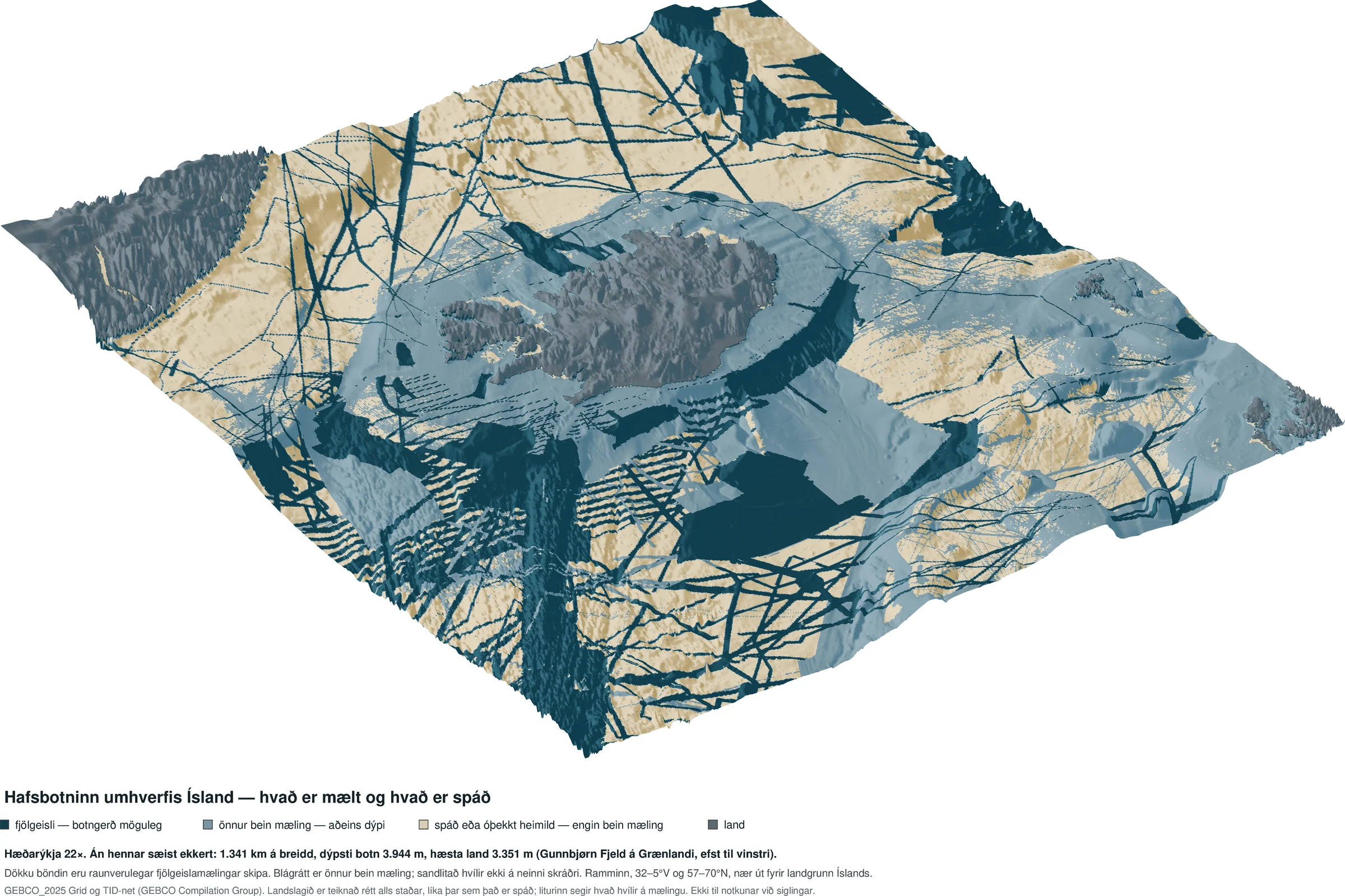
The seabed around Iceland in three dimensions — and how much of it has actually been measured. The terrain is drawn faithfully everywhere; the colour says what lies behind it. Deep teal where a multibeam sonar has passed — the only class from which the substrate could, in principle, be read. Blue-grey where another direct measurement gives the depth but nothing about the bottom; around Iceland's shelf this is mostly GEBCO's "combination of direct measurement methods" class, which does not record which instrument was used. Sand where no direct measurement is recorded behind the depth and it is inferred, mostly from satellite gravity. The dark bands cutting across the image are real ship tracks — each one a multibeam swath. Between them the depth rests either on another direct measurement (blue-grey) or on none that is recorded (sand). Vertical exaggeration is 22×; without it nothing would be visible across 1,341 km of seabed whose deepest point lies 3,944 m down. The frame extends beyond Iceland's shelf: the grey mass at upper left is Greenland, the grey patches at the right edge are the Faroe Islands and, at the far right, north-west Scotland.
Hafsbotninn umhverfis Ísland í þrívídd — og hvað af honum hefur raunverulega verið mælt. Landslagið er teiknað rétt alls staðar, en liturinn segir hvað liggur að baki. Djúpblágrænt þar sem fjölgeislamælir hefur farið yfir — eini flokkurinn þar sem botngerð er yfirhöfuð möguleg. Blágrátt þar sem önnur bein mæling gefur dýpið en ekkert um botninn; á landgrunnshringnum umhverfis Ísland er það að mestu flokkur GEBCO „blanda beinna mæliaðferða", sem skráir ekki hvert tækið var. Sandlitað þar sem engin bein mæling er skráð að baki dýpinu og það er ályktað, að mestu af þyngdarmælingum gervitungla. Dökku böndin sem skera myndina eru raunverulegar siglingarleiðir skipa — hvert band er mælibelti fjölgeislamælis. Utan bandanna hvílir dýpið annaðhvort á annarri beinni mælingu (blágrátt) eða á engri skráðri (sandur). Hæðarýkjan er 22-föld; án hennar sæist ekkert á 1.341 km breiðu svæði þar sem dýpsti botn liggur 3.944 m niðri. Ramminn nær út fyrir landgrunn Íslands: grái massinn efst til vinstri er Grænland, gráu blettirnir við hægri brún eru Færeyjar og lengst til hægri norðvesturhorn Skotlands.
GEBCO Compilation Group (2025), GEBCO 2025 Grid and Type Identifier grid, doi:10.5285/37c52e96-24ea-67ce-e063-7086abc05f29 · vertical exaggeration 22× · viewed from the south-west · the full-size image carries the legend and attribution · September 2026
GEBCO Compilation Group (2025), GEBCO 2025 Grid og TID-net, doi:10.5285/37c52e96-24ea-67ce-e063-7086abc05f29 · hæðarýkja 22× · sjónarhorn frá suðvestri · myndin í fullri stærð ber litaskýringu og heimild · september 2026
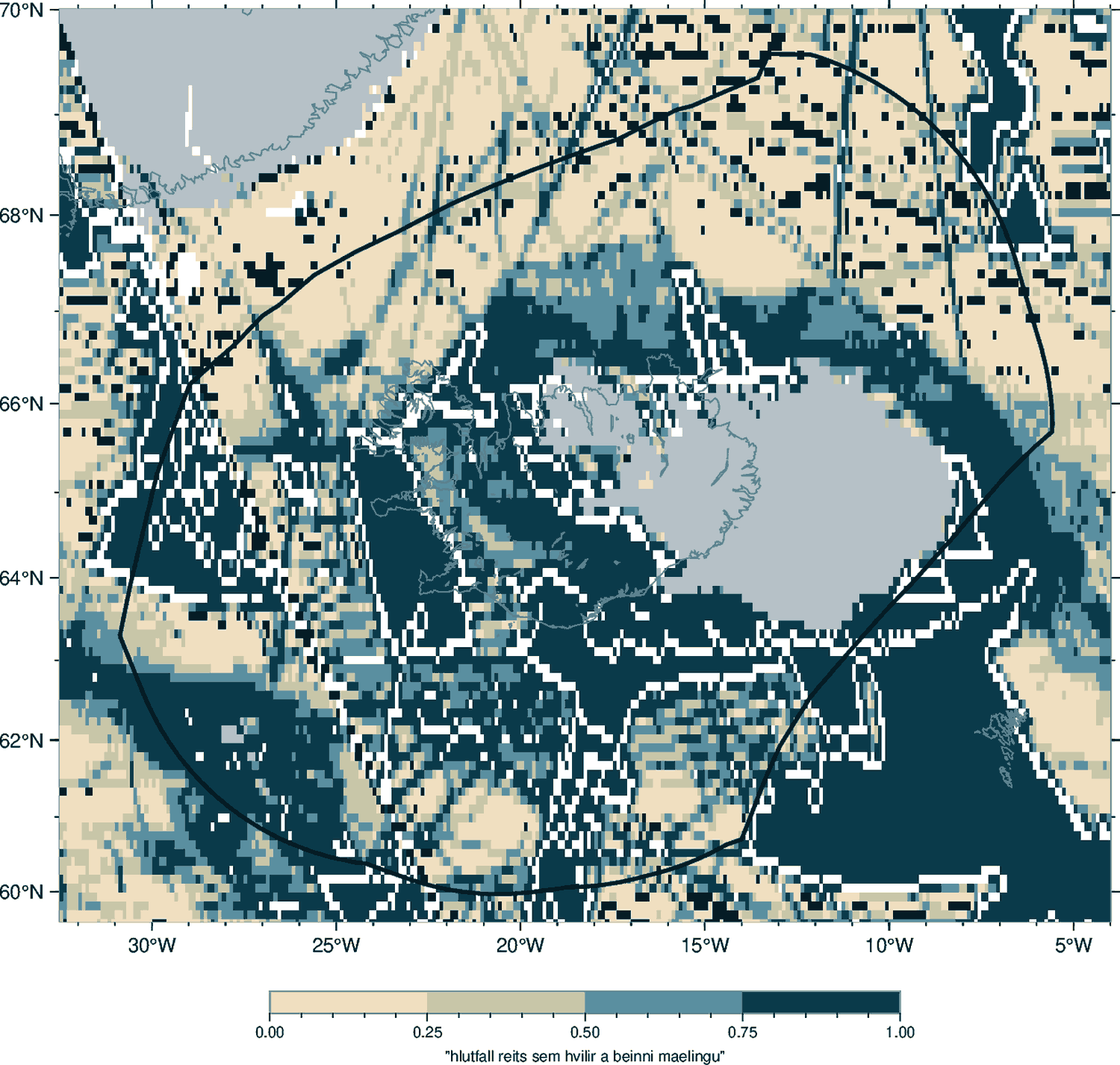
Where the depth of Icelandic waters rests on a real measurement, and where on a prediction. GEBCO records, for every 15-arcsecond cell worldwide, the type of source behind it. Each square here is 0.05° and shaded by the share of it that rests on direct measurement: sand where the depth is inferred from satellite gravity, deep blue where a ship has been. The black line is the 200-nautical-mile boundary. The map is drawn from GEBCO_2025. Inside the 200-mile line, by area: 69.0 per cent measured, 31.0 per cent predicted; across the whole shelf 67.5 and 32.5 per cent. In the 2026 release, published after this map was drawn, the same figures are 69.9 and 30.1 inside the line and 68.6 and 31.4 across the shelf. That measure counts old single-beam and lead-line soundings as measurement. Counting only multibeam, which alone yields substrate, the whole shelf stands at 40.8 per cent and the exclusive economic zone itself at 31.3.
Hvar dýptarlíkan íslenskra hafsvæða byggist á raunverulegri mælingu og hvar á spá. GEBCO skráir fyrir hvern 15 bogasekúndna reit í heiminum hvers konar heimild liggur að baki. Hver ferningur hér er 0,05° og litaður eftir því hversu stór hluti hans hvílir á beinni mælingu: sandur þar sem dýpið er ályktað af þyngdarmælingum gervitungla, djúpblátt þar sem skip hefur farið. Svarta línan er 200 sjómílna markið. Kortið er teiknað eftir GEBCO_2025. Innan 200 mílna, reiknað eftir flatarmáli: 69,0 prósent mæld, 31,0 prósent spáð; yfir allt landgrunnið 67,5 og 32,5 prósent. Í útgáfunni 2026, sem kom út eftir að kortið var teiknað, eru sömu tölur 69,9 og 30,1 innan línunnar og 68,6 og 31,4 yfir landgrunnið allt. Sá mælikvarði telur þó gamlar einsgeisla- og blýlóðsmælingar með. Sé aðeins talinn fjölgeisli, sem einn gefur botngerð, stendur landgrunnið allt í 40,8 prósentum og lögsagan sjálf í 31,3.
"But the Marine and Freshwater Research Institute has been mapping the zone with multibeam since 2017, and the Coast Guard publishes the charts — what is new here?" Three things this map cannot show. Measured is not the same as available: of the multibeam that exists, only a fraction can be obtained by a third party. Available is not the same as comparable: seven datasets from 1987–2018 all carry backscatter, but the oldest instrument's angular response spans 14 dB against 4.9 for a modern one, and nobody has put them on one scale. And the compilation swallows the method: around Iceland's shelf, 99 per cent of the blue-grey cells in the three-dimensional image above are GEBCO's "combination of direct measurement methods" — the grid knows a ship measured there but not with what. The institutions measure. Nobody keeps the inventory of what the measurements add up to, and that is the only thing this project makes.
Measured is not the same as available. This map says somebody has been there. It does not say the data can be obtained, that the seabed's hardness was recorded alongside its depth, or that enough is documented to re-use it. In the international open archive at NOAA, only 19.5 per cent of five-kilometre cells are crossed by a retrievable multibeam survey track at all. The distance between those two numbers is the gap this project exists to close: the seabed has largely been measured, and only a small part of it has been recorded in a way that lets the data be found, quality-graded and re-used.
„En Hafrannsóknastofnun hefur kortlagt lögsöguna með fjölgeisla síðan 2017 og Landhelgisgæslan gefur út sjókortin — hvað er þá nýtt?" Þrennt sem þetta kort getur ekki sýnt. Mælt er ekki það sama og aðgengilegt: af þeim fjölgeisla sem til er nær þriðji aðili aðeins í brot. Aðgengilegt er ekki það sama og samanburðarhæft: sjö gagnasett frá 1987–2018 bera öll bakdreifingu, en hornsvörun elsta tækisins spannar 14 dB á móti 4,9 hjá nútímatæki, og enginn hefur sett þau á einn kvarða. Og samsteypan gleypir aðferðina: á landgrunnshringnum umhverfis Ísland eru 99 prósent blágráu reitanna í þrívíddarmyndinni hér að ofan flokkur GEBCO „blanda beinna mæliaðferða" — netið veit að skip mældi þar en ekki með hverju. Stofnanirnar mæla. Enginn heldur skrána yfir það sem mælingarnar leggjast saman í, og hún er það eina sem þetta verkefni framleiðir.
Mælt er ekki það sama og aðgengilegt. Kortið segir að einhver hafi farið þarna um. Það segir ekki að gögnin fáist, að hörku botnsins hafi verið skráð með dýpinu, eða að nógu vel sé skjalfest til að endurnýta þau. Í opna alþjóðlega safninu hjá NOAA sker fjölgeislamæling sem unnt er að sækja nær aðeins til 19,5 prósent fimm kílómetra reita. Bilið milli þessara talna er gloppan sem verkefnið er til að loka: hafsbotninn hefur að miklu leyti verið mældur, en aðeins lítill hluti hans hefur verið skráður þannig að hægt sé að finna gögnin, gæðaflokka þau og nýta aftur.
GEBCO 2025 Type Identifier grid · EEZ from Marine Regions (MRGID 5680) · area-weighted · September 2026
TID-net GEBCO 2025 · lögsögumörk frá Marine Regions (MRGID 5680) · flatarmálsvegið · september 2026
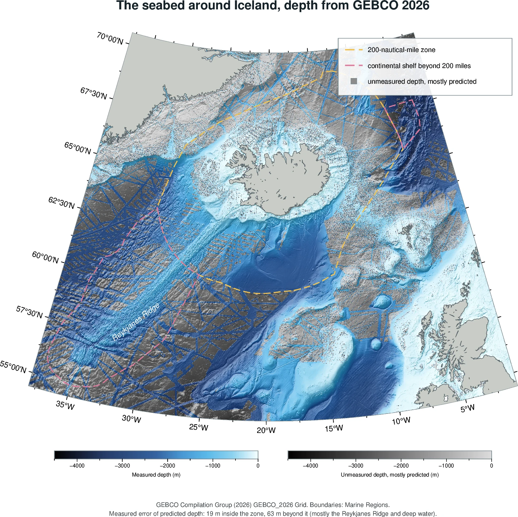
The seabed around Iceland — and how much of its depth was actually measured. Blue where the depth rests on a direct measurement: a ship measured there. Grey where nobody has: the depth is mostly predicted from satellite measurements of the sea surface, and in places interpolated or taken from charts. The relief is drawn everywhere, so the grey areas show the shape of the seabed too — but only coarsely: the prediction cannot see features smaller than a few kilometres. Blue does not mean the seabed type is known. It includes old single-beam soundings and GEBCO's "combination of direct measurement methods", which does not record the instrument. In shallow water both scales run towards white and the difference is hard to see. The dashed yellow line is the 200-nautical-mile zone. The dashed pink line is the continental shelf beyond it: the Reykjanes Ridge to the south-west, on which the UN commission issued recommendations in 2025, and the Ægir Basin to the north-east, on which it issued recommendations in 2016. On the ridge the line follows Iceland's submission as recorded by Marine Regions; the limits finally established on the basis of the recommendations may differ.
How far off is the prediction? Between GEBCO's 2025 and 2026 releases, 13,087 km² of predicted cells on Iceland's shelf were measured with multibeam. Where that happened, the prediction had been off by 19 m on average inside the 200-mile zone and 63 m beyond it, mostly on the Reykjanes Ridge — where even measured cells shift by 11 m between releases, so part of that figure is not the prediction's fault. Across the shelf as a whole there is no large overall bias, and the error grows with how rough the seabed is: 14 m where it is smooth, over 100 m in the roughest places. These cells are where ships chose to go, not a random sample, and most lie deeper than 1,000 m. Where it has been tested, then, the predicted depth is roughly right; what lies on the seabed remains unknown.
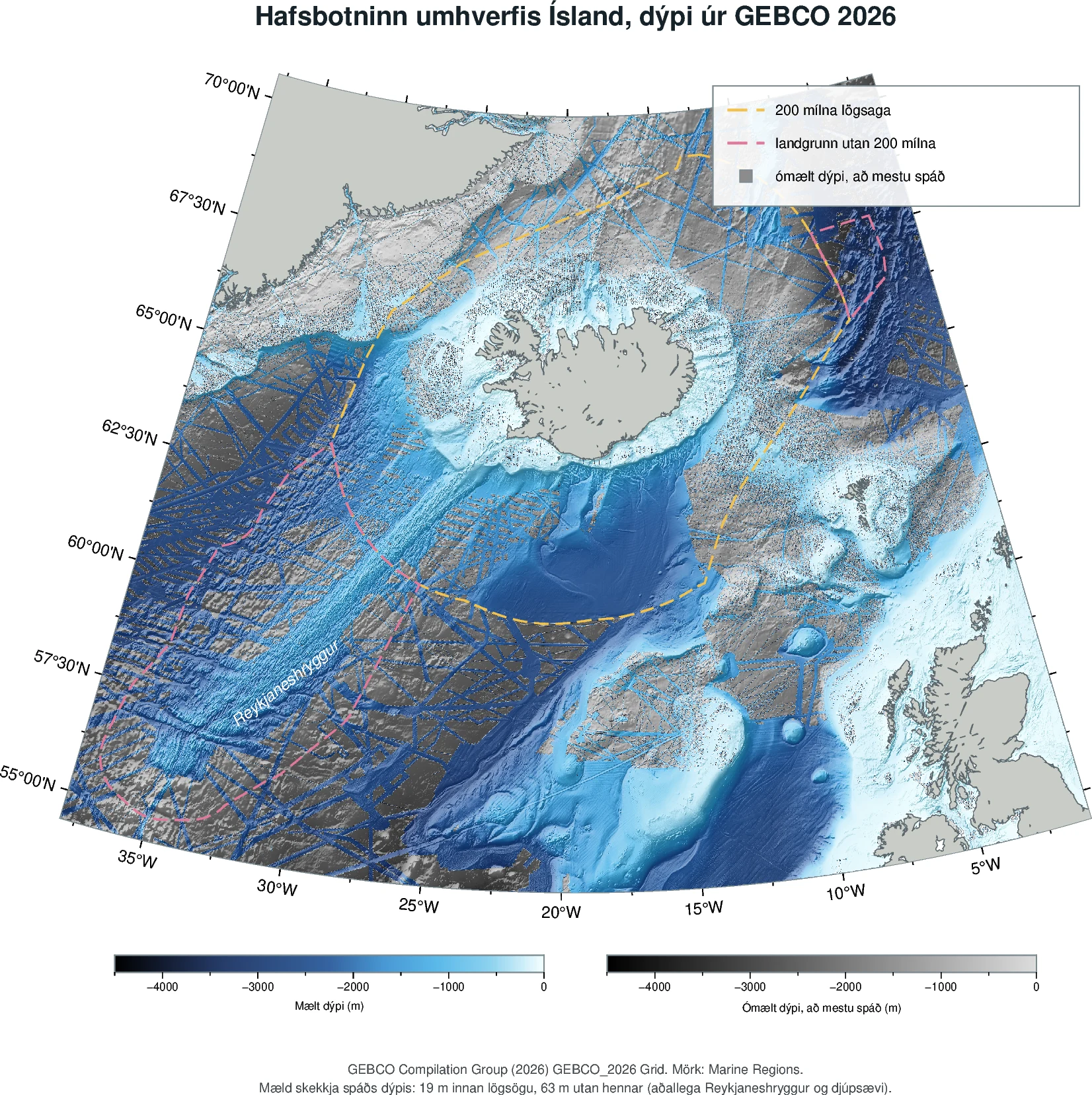
Hafsbotninn umhverfis Ísland — og hve mikið af dýpinu hefur raunverulega verið mælt. Blátt þar sem dýpið hvílir á beinni mælingu: skip mældi þar. Grátt þar sem enginn hefur mælt: dýpinu er að mestu spáð út frá gervihnattamælingum á sjávarborðinu, en sums staðar er það brúað eða tekið af sjókortum. Landslagið er teiknað alls staðar, svo gráu svæðin sýna líka lögun botnsins — en aðeins gróflega: spáin sér ekki fyrirbæri sem eru minni en nokkrir kílómetrar. Blátt þýðir ekki að botngerðin sé þekkt. Þar eru líka gamlar einsgeislamælingar og flokkur GEBCO „blanda beinna mæliaðferða“, sem skráir ekki tækið. Á grunnsævi stefna báðir kvarðarnir í hvítt og munurinn sést illa. Gula strikalínan er 200 sjómílna lögsagan. Bleika strikalínan er landgrunnið utan hennar: Reykjaneshryggur til suðvesturs, sem landgrunnsnefnd SÞ skilaði tillögum um 2025, og Ægisdjúp til norðausturs, sem hún skilaði tillögum um 2016. Á hryggnum fylgir línan greinargerð Íslands eins og Marine Regions skráir hana; endanleg mörk sem ákveðin verða á grundvelli tillagnanna geta orðið önnur.
Hve mikið skeikar spánni? Milli útgáfa GEBCO 2025 og 2026 voru 13.087 km² af spáðum reitum á íslenska landgrunninu mældir með fjölgeisla. Þar hafði spánni skeikað að meðaltali um 19 m innan lögsögunnar og 63 m utan hennar, að mestu á Reykjaneshrygg — þar sem jafnvel mældir reitir breytast um 11 m milli útgáfa, svo hluti þeirrar tölu skrifast ekki á spána. Yfir landgrunnið allt er engin teljandi kerfisbundin skekkja, og skekkjan vex með óreglu botnsins: 14 m þar sem hann er sléttur, yfir 100 m þar sem hann er úfnastur. Þessir reitir eru þar sem skip kusu að sigla, ekki slembiúrtak, og flestir liggja dýpra en 1.000 m. Þar sem þetta hefur verið prófað er spáða dýpið því nærri lagi; það sem liggur á botninum er enn óþekkt.
GEBCO Compilation Group (2026), GEBCO_2026 Grid and Type Identifier grid, doi:10.5285/4f68d5c7-45eb-f999-e063-7086abc036fa · boundaries from Marine Regions (MRGID 5680, 64170, 64725) · error measured where 2025 predicted cells became 2026 multibeam · October 2026
GEBCO Compilation Group (2026), GEBCO_2026 Grid og TID-net, doi:10.5285/4f68d5c7-45eb-f999-e063-7086abc036fa · mörk frá Marine Regions (MRGID 5680, 64170, 64725) · skekkja mæld þar sem spáðir reitir 2025 urðu fjölgeisli 2026 · október 2026
Sixteen research cruises, found in a single archive. Each dot is one expedition that crossed the Reykjanes Ridge and recorded the seabed on the way past, across three generations of instrument. None was sent to survey it. The measurements exist and are free to download — what has never been done is to put them together and ask what they add up to.
Sextán rannsóknarleiðangrar, fundnir í einu gagnasafni. Hver punktur táknar einn leiðangur sem fór yfir Reykjaneshrygg og skráði hafsbotninn á leiðinni, með þremur kynslóðum mælitækja. Enginn þeirra var sendur til að kortleggja hrygginn. Mælingarnar eru til og hægt er að sækja þær ókeypis — en aldrei hefur verið ráðist í að taka þær saman og kanna hvaða heildarmynd þær gefa.
Source: NCEI cruise-track query, September 2026
Heimild: leit NCEI í ferlum rannsóknarleiðangra, september 2026
Applications
Notkunarmöguleikar
The same inventory supports several kinds of decision
Sama skráin svarar mörgum spurningum
Planning for every subsea cable, offshore wind farm and aquaculture site begins with a desktop study: an assessment of existing seabed data before a survey vessel is commissioned. The quality of that study determines how many ship days the survey needs, and ship days are the dominant cost.
Undirbúningur sérhvers sæstrengs, vindorkuvers á hafi og fiskeldissvæðis hefst með skrifborðsathugun: mati á fyrirliggjandi gögnum um hafsbotninn áður en rannsóknarskip er fengið til verksins. Gæði athugunarinnar ráða því hversu marga skipdaga rannsóknin krefst, en skipdagar eru langstærsti kostnaðarliðurinn.
One body of evidence, four groups of users. Substrate, slope, sediment thickness and geohazards are the same inputs whichever question is being asked. Only the interpretation layer on top differs — which is why the inventory holds its value whatever the answer turns out to be.
Eitt mælingasafn, fjórir kaupendur. Botngerð, halli, þykkt setlaga og jarðvá eru sömu grunngögnin, óháð því hvaða spurningar er spurt. Aðeins túlkunarlagið ofan á er ólíkt — þess vegna heldur skráin gildi sínu, hver sem niðurstaðan reynist vera.
| Layer | Status | Rests on | What is missing |
|---|---|---|---|
| Substrate | Prototype on the Reykjanes Ridge | Relative, uncalibrated backscatter from seven datasets, 1987–2018 | Cross-instrument calibration; ground truth from samples. This is not yet substrate in the sense a cable plough needs |
| Slope | Derived where depth exists | GEBCO grid; multibeam where available | Positional uncertainty of older surveys — a 200 m lateral error moves a feature across a route |
| Sediment | Not built | — | Sub-bottom profiler data. MSM75 and AR30 carry it and it has not been opened |
| Geohazards | Not built | ISC earthquake catalogue used only for target selection | Slope stability, volcanic hazard, fault mapping |
One of four layers exists as a tested prototype. The figure above shows what the inventory is designed to hold, not what it holds today.
| Lag | Staða | Hvílir á | Hvað vantar |
|---|---|---|---|
| Botngerð | Frumgerð á Reykjaneshrygg | Afstæð, ókvörðuð bakdreifing sjö gagnasetta, 1987–2018 | Kvörðun milli tækja; staðfesting með sýnum. Þetta er ekki enn botngerð í þeim skilningi sem strengplógur þarf |
| Halli | Reiknaður þar sem dýpi er til | GEBCO-net; fjölgeisli þar sem hann er | Staðsetningaróvissa eldri mælinga — 200 m hliðarskekkja færir fyrirbæri yfir leið |
| Setlög | Ekki byggt | — | Botnsjármælingar. MSM75 og AR30 bera þær og þær hafa ekki verið opnaðar |
| Jarðvá | Ekki byggt | Skjálftaskrá ISC, aðeins notuð til markmiðavals | Stöðugleiki halla, gosvá, kortlagning misgengja |
Eitt af fjórum lögum er til sem prófuð frumgerð. Myndin hér að ofan sýnir hvað skránni er ætlað að bera, ekki hvað hún ber í dag.
| Application | What the inventory answers |
|---|---|
| Cable and pipeline routing | Where existing data is good enough to route on, where new survey is required, and which hazards it must cover See a sample deliverable → |
| Offshore wind and aquaculture siting | Depth, slope and relief with a confidence value attached, plus substrate indicators for anchoring and burial |
| Undersea infrastructure protection | Detecting change requires a reliable baseline. The inventory provides that baseline and states its uncertainty |
| Resource assessment | The first application of the method — demonstrating its value by systematically eliminating unsupported targets rather than producing another list of possibilities |
| Habitat mapping and marine planning | Substrate classification is the core input to both, and both are legal obligations across the European Economic Area |
| Notkun | Hverju skráin svarar |
|---|---|
| Leiðarval sæstrengja og leiðslna | Hvar fyrirliggjandi gögn nægja til leiðarvals, hvar nýrrar könnunar er þörf og hvaða hættuþætti ný könnun þarf að ná yfir Sjá sýnisafurð → |
| Staðarval vindorkuvera á hafi og fiskeldisstöðva | Dýpt, halli og landslag ásamt tilgreindu áreiðanleikamati, auk vísbendinga um botngerð vegna festinga og niðurgraftar |
| Vernd neðansjávarinnviða | Breytingar eru greindar með samanburði og því þarf fyrri mælingu til viðmiðunar. Þetta er sú viðmiðun, með tilgreindri óvissu |
| Auðlindamat | Fyrsta notkunin — og sú sem prófaði aðferðina með því að tæma leitarsvæði í stað þess að staðfesta tiltekna niðurstöðu |
| Kortlagning búsvæða og hafskipulag | Flokkun botngerðar er lykilinntak í hvort tveggja og hvort tveggja er lagaleg skylda á öllu Evrópska efnahagssvæðinu |
This does not replace a project-specific marine survey. No open dataset can. It reduces the area that needs new survey, identifies data gaps and hazards earlier, and sharpens the specification of the survey that is commissioned. It sits upstream of project-specific marine surveying and complements survey companies rather than competing with them.
Þetta kemur ekki í stað sjómælinga sem gerðar eru fyrir einstök verkefni. Ekkert opið gagnasafn getur gert það. Það minnkar svæðið sem þarf að mæla að nýju, greinir fyrr gloppur í gögnum og hættuþætti og gerir verklýsingu fyrir fyrirhugaða könnun nákvæmari. Þetta er skrefið á undan mælingafyrirtækjunum, ekki samkeppni við þau.
What has been done
Hvað hefur verið gert
Four target areas, assessed from raw data to final decision
Fjögur markmiðssvæði, metin frá hrágögnum til endanlegrar niðurstöðu
The method is not a proposal. It has been built and run, on the Reykjanes Ridge south of 61°N, using nothing but data that was already public and free.
Aðferðin er ekki tillaga. Hún hefur verið þróuð og prófuð á Reykjaneshrygg sunnan 61°N, eingöngu með gögnum sem þegar voru opinber og ókeypis.
Four target areas were selected from the international earthquake catalogue — spots where persistent small tremors suggest something may still be circulating under the seabed. Each was measured against everything the open archives held: 33 gigabytes of raw data across four generations of instrument, from 1987 to 2018, and fifteen million individual soundings.
All four came back negative: no convincing acoustic evidence, and the candidates that did appear turned out not to stand out from ordinary seabed nearby. That is not the same as proving nothing is there. Sound cannot tell sulphide from bare basalt, so what has been established is that the available open measurements do not suffice to settle the question — and exactly what kind of measurement would.
Fjórir staðir voru valdir úr alþjóðlegri jarðskjálftaskrá — staðir þar sem viðvarandi smáskjálftar gefa til kynna að enn kunni að vera hringrás undir hafsbotninum. Hver staður var borinn saman við allt sem var að finna í opnum gagnasöfnum: 33 gígabæti af hráum gögnum frá fjórum kynslóðum mælitækja, frá 1987 til 2018, og fimmtán milljónir einstakra dýptarmælinga.
Öll fjögur skiluðu neikvæðri niðurstöðu: engin sannfærandi hljóðfræðileg vísbending, og þau frávik sem komu upp reyndust ekki skera sig frá venjulegum botni í grenndinni. Það er ekki það sama og að sanna að þar sé ekkert. Hljóð getur ekki greint súlfíð frá berum basalti, svo það sem hefur verið staðfest er að fyrirliggjandi opnar mælingar nægja ekki til að skera úr — og nákvæmlega hvers konar mæling myndi gera það.
That is the result, and it is a real one. A verified no is worth more to somebody about to spend money than an unverified maybe. It says: this has been looked at properly, here is what was used, and here is why it did not suffice. Nobody has to look again from scratch.
The whole exercise used no ship time and no funding.
Þetta er niðurstaðan og hún er raunveruleg. Staðfest nei er verðmætara fyrir þann sem hyggst verja fé en óstaðfest kannski. Það segir: Þetta hefur verið kannað með fullnægjandi hætti, hér er það sem var notað og hér er ástæða þess að það nægði ekki. Enginn þarf að hefja leitina aftur frá grunni.
Öll vinnan var unnin án skipatíma og án fjármögnunar.
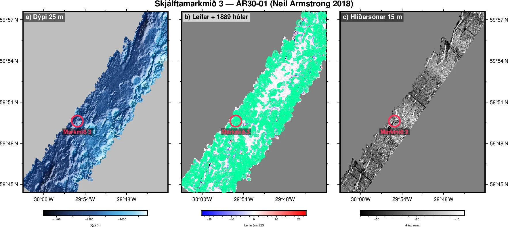
What the seabed looks like when somebody has actually measured it. These three panels are one of the four places, from a research vessel that passed over it in 2018. Everything grey is unmeasured — and grey is what most of the shelf looks like.
Svona lítur hafsbotninn út þegar hann hefur í raun verið mældur. Þessir þrír myndhlutar sýna einn staðanna fjögurra, byggt á mælingum rannsóknarskips sem fór þar yfir árið 2018. Allt sem er grátt er ómælt — og megnið af landgrunninu er grátt.
AR30-01 · Neil Armstrong 2018 · click for full resolution
AR30-01 · Neil Armstrong 2018 · smellið til að sjá fulla upplausn
One of the four is written up in full — why it was selected, what had been measured, what the analysis first suggested, and why that apparent result was rejected: a worked example.
Gerð hefur verið ítarleg grein fyrir einum staðanna fjögurra — hvað beindi athyglinni að honum, hvað var mælt, hvað kom í ljós og hvað varð til þess að niðurstöðunni var hafnað: fullunnið dæmi.
Why this can be trusted
Hvers vegna má treysta þessu
The value lies in what the method rejects
Verðmætið felst í því sem aðferðin útilokar
Anybody can produce a list of interesting places on a map. A method that never says no is worth nothing, because every false lead it passes on costs somebody a day of ship time — and a single survey day can cost more than a new car.
Hver sem er getur sett saman lista yfir áhugaverða staði á korti. Aðferð sem segir aldrei nei er einskis virði, því hver fölsk vísbending sem hún sendir áfram kostar kaupandann skipdag — og einn mælingadagur kostar meira en bílar flestra.
Seven times this method produced something that looked convincing, and then removed it. Three of those were its own strongest results at the time.
Sjö sinnum skilaði aðferðin einhverju sem virtist sannfærandi en útilokaði það síðan. Þrjú tilvikanna voru sterkustu niðurstöður verkefnisins á þeim tíma.
A mound 79 metres high and 60 metres wide. It was the side of a 288-metre hill, and 8,898 raw measurements said so.
Twenty-eight strong reflections that could have indicated hard or metal-rich ground. Four out of five of them sat at the far edge of the sonar beam, where measurements are known to be less reliable.
A result that was statistically certain. Treating each pixel as an independent observation gave a nominal sample of sixty-four thousand. Using the independently calibrated source files as the statistical unit reduced it to five.
Hóll, 79 metra hár og 60 metra breiður. Hann reyndist vera hluti af hlíð 288 metra hárrar hæðar og 8.898 hráar mælingar sýndu það.
Tuttugu og átta sterk endurvörp sem gátu bent til harðs eða málmríks efnis. Fjögur af hverjum fimm voru yst á jaðri sónargeislans, þar sem mælitækinu er ekki treystandi.
Niðurstaða sem var tölfræðilega örugg. Með einni talningaraðferð studdust 64 þúsund mælingar við hana. Með réttri talningaraðferð voru þær fimm.
Every result in the inventory is accompanied by a documented reason for its acceptance or rejection, and the discard log is a deliverable in its own right. That is the difference between a record somebody can act on and a list somebody has to check.
Sérhverri niðurstöðu í Landgrunnsskránni fylgir ástæða þess að henni var haldið eða hafnað og höfnunarskráin er sjálfstæð afurð. Þar liggur munurinn á skrá sem hægt er að byggja ákvörðun á og lista sem einhver þarf sjálfur að yfirfara.
The full rejection record, the five processing steps and the technical detail are on a separate page: how the method works.
Heildarskrá yfir hafnanir, vinnsluþrepin fimm og tæknileg atriði eru á sérstakri síðu: hvernig aðferðin virkar.
Status and contact
Staða og samband
Where the work stands
Hvar verkefnið stendur
The prototype is built and tested. It processes every historical multibeam and sidescan format encountered in the open datasets examined on the ridge, including a 1994 EM12 dataset whose published format identifier was wrong. All four targets on the Reykjanes Ridge have been screened, three of them against two matched reference areas each. Every rejection above is reproducible from open data with the scripts that produced it.
The next step is to test whether the workflow transfers to a second sea area with different geology and an immediate commercial use case. The product metric is the reduction in analyst hours relative to a conventional desktop study.
The project is looking for three things — a first commercial client for a desktop study, research funding for the near-seabed geophysical measurements the Reykjanes result identifies as the necessary next step, and technical review of the method.
Frumgerðin hefur verið smíðuð og prófuð. Hún les öll söguleg snið fjölgeisla- og hliðarsónargagna á hryggnum, þar á meðal EM12-gagnasafn frá 1994 þar sem birt auðkenni gagnasniðsins var rangt. Öll fjögur markmiðin á Reykjaneshrygg hafa verið könnuð, og þrjú þeirra voru jafnframt borin saman við tvo samsvarandi viðmiðunarreiti. Allar hafnanirnar hér að framan má endurgera úr opnum gögnum með forskriftunum sem skiluðu þeim.
Næst tekur við yfirfærsla: að keyra sama verkferli á öðru hafsvæði með annars konar jarðfræði og fyrirliggjandi viðskiptalega þörf og mæla hversu mörgum vinnustundum verkferlið sparar. Sú tala er árangursmælikvarði afurðarinnar.
Verkefnið leitar að þrennu — fyrsta skrifborðsathugunarverkefninu á markaði, rannsóknarstyrk fyrir þá mælingu nærri hafsbotni sem niðurstaðan á Reykjaneshrygg kallar nú eftir og tæknilegri rýni á aðferðinni.
arnar@landgrunn.is · Reykjavík, Ísland