A sample deliverable · synthetic test section
Sýnisafurð · tilbúinn prófunarkafli
What a route screening deliversHvað skrifborðsathugun á strengleið skilar
This is a synthetic test section, not a real route. The 200 km line on this page runs from off the south coast of Iceland towards the south-east. It was drawn for one purpose: to show what the deliverable looks like. It is not the route of any cable, planned or laid; no client supplied its coordinates; and nothing about it should be read as information about any real project.
Þetta er tilbúinn prófunarkafli, ekki raunveruleg leið. 200 km línan á þessari síðu liggur frá hafinu undan Suðurlandi til suðausturs. Hún var dregin í einum tilgangi: að sýna hvernig afurðin lítur út. Hún er ekki leið nokkurs strengs, hvorki fyrirhugaðs né lagðs; enginn kaupandi lét hnit hennar af hendi; og ekkert í henni ber að lesa sem upplýsingar um raunverulegt verkefni.
Every subsea cable begins with a desktop study: an assessment of what is already known about the seabed along the route before a survey vessel is chartered. This page shows the three things such a screening delivers, run end to end on the test section with open data only.
Undirbúningur sérhvers sæstrengs hefst með skrifborðsathugun: mati á því sem þegar er vitað um hafsbotninn eftir leiðinni áður en rannsóknarskip er tekið á leigu. Hér er sýnt það þrennt sem slík athugun skilar, keyrt frá upphafi til enda á prófunarkaflanum með opnum gögnum einum.
The section is 200 km long and the corridor around it reaches 10 km to either side. Ten kilometres is chosen because existing measurements never lie exactly on a planned route; what matters at the desktop stage is whether anything usable lies nearby. A narrower corridor gives a false "nothing exists", a wider one a false "this is covered". Coverage is counted per route kilometre, not per square kilometre, because a cable follows a line.
Two open sources feed everything below: the GEBCO 2026 Type Identifier grid, which records for every cell what kind of measurement lies behind the depth, and the multibeam cruise-track service of NOAA's National Centers for Environmental Information, NCEI. No data was requested from anyone.
Kaflinn er 200 km langur og gangurinn umhverfis hann nær 10 km til hvorrar hliðar. Tíu kílómetrar eru valdir vegna þess að fyrirliggjandi mælingar liggja aldrei nákvæmlega á fyrirhugaðri leið; það sem skiptir máli á skrifborðsstigi er hvort nokkuð nothæft sé í nágrenninu. Þrengri gangur gefur falskt „ekkert til", breiðari gefur falskt „þetta er þakið". Þekjan er talin eftir leiðarkílómetrum, ekki ferkílómetrum, því strengur fylgir línu.
Tvær opnar heimildir liggja að baki öllu hér að neðan: TID-net GEBCO 2026, sem skráir fyrir hvern reit hvers konar mæling liggur að baki dýpinu, og siglingarlínuþjónusta NCEI, gagnamiðstöðvar NOAA, yfir fjölgeislaleiðangra. Engra gagna var óskað frá neinum.
Deliverable 1
Afurð 1
What has been measured along the section, and with what
Hvað hefur verið mælt eftir kaflanum, og með hverju
The map answers the first question a route engineer asks: is there anything here at all? The colour under the line says what kind of measurement the depth rests on; the tracks across it say which cruises actually passed through the corridor.
Kortið svarar fyrstu spurningu leiðarhönnuðar: er nokkuð til hér? Liturinn undir línunni segir hvers konar mæling liggur að baki dýpinu; línurnar þvert yfir segja hvaða leiðangrar fóru í reynd um ganginn.
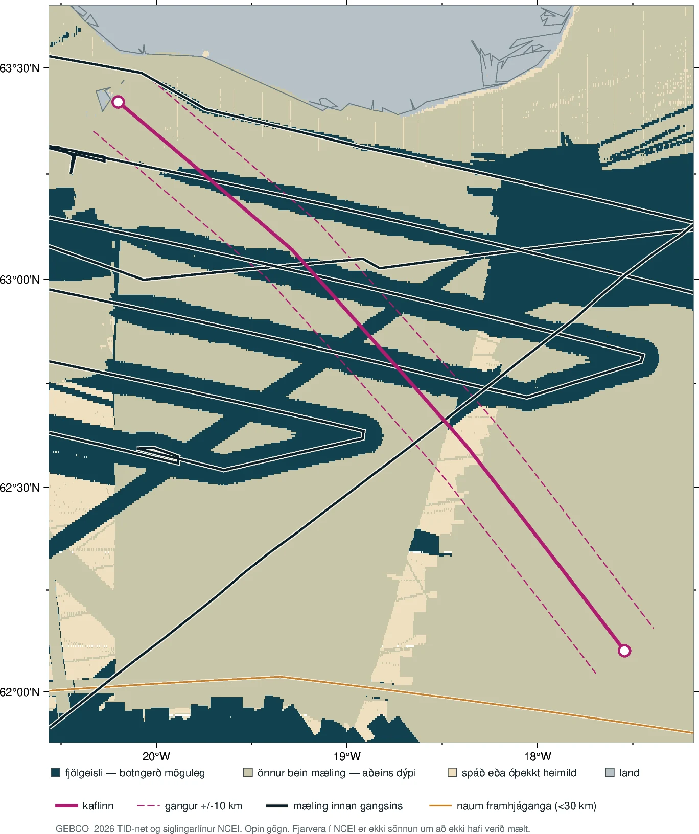
Coverage map of the synthetic test section. The section is made up; it is not any cable's route. The magenta line is the section, 200 km from off the south coast towards the south-east, with a circle at each end. The dashed magenta lines are the corridor, 10 km to either side. The seabed is coloured by what lies behind the GEBCO depth: deep teal where a multibeam sonar has passed, the only class from which substrate could in principle be read; grey-green where another direct measurement, method unspecified, gives the depth but nothing about the bottom; sand where no direct measurement lies behind the depth — predicted from satellite gravity or taken from a chart; grey-blue is land. The dark lines with a pale casing are the tracks of the three cruises that lie within the corridor — from 1990, 2007 and 2019. Their survey lines cross the section and the corridor repeatedly over its northern 130 km, over the multibeam fields: 121 of the 200 kilometres have a multibeam track somewhere within the corridor. South of about 62°35′N — the last 70 km — there is none. The orange line along the bottom edge of the map is a near miss: a 1990 cruise that passes south of the section's south-eastern end, 21 km away at its closest, and never enters the corridor. The legend printed on the map itself is in Icelandic; the colours are explained here.
Þekjukort prófunarkaflans. Kaflinn er tilbúinn; hann er ekki leið nokkurs strengs. Blárauða línan er kaflinn, 200 km frá hafinu undan Suðurlandi til suðausturs, með hring á hverjum enda. Blárauðu strikalínurnar eru gangurinn, 10 km til hvorrar hliðar. Hafsbotninn er litaður eftir því hvað liggur að baki GEBCO-dýpinu: djúpblágrænt þar sem fjölgeislamælir hefur farið yfir, eini flokkurinn þar sem botngerð er yfirhöfuð læsileg; grágrænt þar sem önnur bein mæling, aðferð ótilgreind, gefur dýpið en ekkert um botninn; sandlitað þar sem engin bein mæling liggur að baki dýpinu — það er spáð úr þyngdarmælingum gervitungla eða tekið af korti; blágrátt er land. Dökku línurnar með ljósri kápu eru siglingarlínur leiðangranna þriggja sem liggja innan gangsins — frá 1990, 2007 og 2019. Mælilínur þeirra skera kaflann og ganginn margsinnis á nyrstu 130 kílómetrunum, yfir fjölgeislaflötunum: 121 af 200 kílómetrum leiðarinnar hafa fjölgeislalínu einhvers staðar innan gangsins. Sunnan við um 62°35′N — síðustu 70 km — er engin. Appelsínugula línan neðst á kortinu er naum framhjáganga: leiðangur frá 1990 sem fer sunnan við suðausturenda kaflans, næst 21 km frá honum, og fer aldrei inn í ganginn.
GEBCO Compilation Group (2026), GEBCO 2026 Type Identifier grid, doi:10.5285/4f68d5c7-45eb-f999-e063-7086abc036fa · NCEI multibeam cruise-track service · corridor ±10 km · synthetic section, no source · click for full resolution · September 2026
GEBCO Compilation Group (2026), TID-net GEBCO 2026, doi:10.5285/4f68d5c7-45eb-f999-e063-7086abc036fa · siglingarlínuþjónusta NCEI · gangur ±10 km · tilbúinn kafli, engin heimild · smellið til að sjá fulla upplausn · september 2026
Deliverable 2
Afurð 2
Depth says where the cable lies. Substrate says whether it can be buried.
Dýpi segir hvar strengurinn liggur. Botngerð segir hvort hann grefst.
A depth value exists for the whole section. That is not the same as knowing the seabed. Of the three classes on the map, only multibeam sonar records the strength of the returned echo alongside the depth, and only that return can in principle be read for hardness. Counted over the 200 route kilometres, one sample per kilometre:
Dýptargildi er til fyrir allan kaflann. Það er ekki það sama og að þekkja hafsbotninn. Af flokkunum þremur á kortinu skráir fjölgeislamælir einn styrk endurvarpsins ásamt dýpinu, og aðeins það endurvarp er yfirhöfuð læsilegt sem harka. Talið eftir 200 kílómetrum leiðarinnar, eitt sýni á kílómetra:
| Class | km | Share |
|---|---|---|
| Multibeam — substrate possible | 45 | 22.5% |
| Other direct measurement, method unspecified — depth only | 142 | 71.0% |
| Predicted, interpolated or unknown source — no direct measurement | 13 | 6.5% |
| Other or unclassified | 0 | 0.0% |
| Flokkur | km | Hlutfall |
|---|---|---|
| Fjölgeisli — botngerð möguleg | 45 | 22,5% |
| Önnur bein mæling, aðferð ótilgreind — aðeins dýpi | 142 | 71,0% |
| Spáð, brúað eða óþekkt heimild — engin bein mæling | 13 | 6,5% |
| Annað eða óflokkað | 0 | 0,0% |
GEBCO 2026 Type Identifier grid, read under each of 200 points spaced one kilometre apart along the section · multibeam is TID code 11 · September 2026
TID-net GEBCO 2026, lesið undir 200 punktum með kílómetra millibili eftir kaflanum · fjölgeisli er TID-kóði 11 · september 2026
The GEBCO codes under the 200 kilometres, so that it is visible what was counted: TID 11 under 45 km, TID 17 under 142 km, TID 40 under 12 km, TID 42 under 1 km. All 142 km of the second class are TID 17, "combination of direct measurement methods": the grid records that the depth was measured directly, not with what instrument. The third class is 12 km predicted from satellite gravity and 1 km of depth contours digitised from a chart.
TID-kóðar GEBCO undir kílómetrunum 200, svo sjáist hvað var talið: 11 undir 45 km, 17 undir 142 km, 40 undir 12 km, 42 undir 1 km. Allir 142 kílómetrar annars flokks eru TID 17, „blanda beinna mæliaðferða": netið skráir að dýpið var mælt beint en ekki með hvaða tæki. Þriðji flokkurinn er 12 km spáð úr þyngdarmælingum gervitungla og 1 km dýptarlína af korti.
77.5 per cent of the section has no substrate from open data. Depth says where the cable lies; substrate says whether it can be buried. On more than three quarters of this section the second question cannot be answered from anything in the open archives — and knowing that before the survey is specified is what the screening is for.
77,5 prósent kaflans hafa enga botngerð úr opnum gögnum. Dýpi segir hvar strengurinn liggur; botngerð segir hvort hann grefst. Á meira en þremur fjórðu kaflans er síðari spurningunni ósvarað úr öllu því sem liggur í opnum söfnum — og að vita það áður en könnunin er skilgreind er það sem athugunin er til.
Deliverable 3
Afurð 3
Datasets that appear to cover the section, and do not
Gagnasett sem líta út fyrir að ná yfir kaflann en gera það ekki
Archives are searched with a rectangle. Ask NCEI for every cruise that touches a box drawn around the corridor and the answer is five. The box is the problem: around a 200 km section that runs diagonally, the enclosing rectangle reaches tens of kilometres from the section at its corners, and a cruise that touches a corner comes up as if it concerned the route. The screening therefore runs both tests on purpose: the box search, which is what a careless search returns, and the corridor test, which measures the distance from the cruise tracks themselves — densified to a point every 0.5 km, so that distance is measured along the legs and not only at their vertices — to the section, and counts the length of track lying within 10 km. The difference between the two lists is this deliverable.
Leitað er í söfnum með ramma. Sé NCEI spurt um alla leiðangra sem snerta ramma utan um ganginn er svarið fimm. Ramminn er vandinn: utan um 200 km kafla sem liggur á ská er leitarramminn rétthyrningur sem nær tugi kílómetra frá kaflanum í hornunum, og leiðangur sem snertir hornið kemur upp eins og hann varði leiðina. Athugunin keyrir því bæði prófin viljandi: rammaleitina, sem er það sem óvarkár leit skilar, og gangaprófunina, sem mælir fjarlægð frá siglingarlínunum sjálfum — þéttum á 0,5 km bili, svo fjarlægðin sé mæld eftir leggjunum og ekki aðeins í hnitum þeirra — að kaflanum og telur lengd siglingarlínu innan 10 km. Mismunurinn á listunum tveimur er þessi afurð.
Of the five cruises the box search returned, three lie within the corridor, one passes just outside it, and one is nowhere near.
Af leiðöngrunum fimm sem rammaleitin skilaði liggja þrír innan gangsins, einn fer rétt utan hans og einn er hvergi nærri.
False positives — more than 30 km from the section
Falsjákvæð — lengra en 30 km frá kaflanum
These come up in the box search and carry no data that concerns the section.
Þessi koma upp í rammaleit en bera engin gögn sem varða kaflann.
| Cruise | Year | Instrument | Vessel | Nearest to section |
|---|---|---|---|---|
| KN166L13 | 2002 | SeaBeam 2112 | Knorr | 90 km |
| Leiðangur | Ár | Tæki | Skip | Næst kaflanum |
|---|---|---|---|---|
| KN166L13 | 2002 | SeaBeam 2112 | Knorr | 90 km |
Near misses — 10 to 30 km from the section
Naumar framhjágöngur — 10 til 30 km frá kaflanum
Not false positives but edge cases. They could become useful if the corridor were widened, and they are listed separately so that the count above is not inflated.
Ekki falsjákvæð heldur jaðartilvik. Þau gætu nýst ef gangurinn væri breikkaður, og þau eru talin sérstaklega svo talan hér að ofan sé ekki ýkt.
| Cruise | Year | Instrument | Vessel | Nearest to section |
|---|---|---|---|---|
| EW9008 | 1990 | Atlas Hydrosweep DS | Maurice Ewing | 21 km |
| Leiðangur | Ár | Tæki | Skip | Næst kaflanum |
|---|---|---|---|---|
| EW9008 | 1990 | Atlas Hydrosweep DS | Maurice Ewing | 21 km |
Cruises that lie within the corridor
Leiðangrar sem liggja innan gangsins
| Cruise | Year | Instrument | Vessel | km in corridor | Nearest to section |
|---|---|---|---|---|---|
| KN189-04 | 2007 | SeaBeam 3012 | Knorr | 123 | 0.0 km |
| EW9006 | 1990 | Atlas Hydrosweep DS | Maurice Ewing | 25 | 0.2 km |
| PD19T501 | 2019 | Kongsberg EM124 | Pressure Drop | 20 | 0.1 km |
| Leiðangur | Ár | Tæki | Skip | km í gangi | Næst kaflanum |
|---|---|---|---|---|---|
| KN189-04 | 2007 | SeaBeam 3012 | Knorr | 123 | 0,0 km |
| EW9006 | 1990 | Atlas Hydrosweep DS | Maurice Ewing | 25 | 0,2 km |
| PD19T501 | 2019 | Kongsberg EM124 | Pressure Drop | 20 | 0,1 km |
NCEI multibeam cruise-track service, box search over the corridor, then distance from every cruise track, densified to one point per 0.5 km, to the section · September 2026
Siglingarlínuþjónusta NCEI, rammaleit yfir ganginn og síðan fjarlægð hverrar siglingarlínu, þéttrar á 0,5 km bili, að kaflanum · september 2026
"km in corridor" is the summed length of a cruise's track inside the corridor, not the length of section it covers. Survey lines are run back and forth and each pass counts on its own; 123 km of track from one cruise does not mean that 123 of the 200 route kilometres have been sounded. The map above shows where the track actually falls.
„km í gangi" er samanlögð lengd siglingarlínu leiðangursins innan gangsins, ekki hve langan hluta kaflans hann þekur. Mælilínur eru sigldar fram og aftur og hver ferð telur fyrir sig; 123 km af siglingarlínu frá einum leiðangri merkja ekki að 123 af 200 kílómetrum leiðarinnar hafi verið mældir. Kortið hér að ofan sýnir hvar línan liggur í reynd.
The project made this mistake itself before it made it a deliverable. In a search over the Reykjanes Ridge, cruises NA138 and NA143 came up as covering two of the target areas; the data turned out to be from the Pacific Ocean. That is entry 03 in the rejection record. Deliverable 3 is the same error, caught the same way, applied to every cruise the archive returns for a section.
Verkefnið gerði þessa villu sjálft áður en það gerði hana að afurð. Í leit yfir Reykjaneshrygg komu leiðangrarnir NA138 og NA143 upp sem þekja á tveimur markmiðanna; gögnin reyndust úr Kyrrahafinu. Það er færsla 03 í höfnunarskránni. Afurð 3 er sama villan, gripin á sama hátt, í hverjum þeim leiðangri sem safnið skilar fyrir kafla.
The same rule was applied to this page before it was published. The first run of this analysis marked KN189-04 as "0 km in corridor, 9.7 km from the section" and EW9006 as a near miss at 12 km. Both cruises cross the section. Two errors in the script were found in an independent review before anything was published. Every cruise was counted once for each search tile it touched, so its kilometres in the corridor were counted several times over — fivefold on this section. And distance was measured only at the vertices of each track leg — NCEI stores legs up to 283 km long — so a leg that cut across the section between two vertices was measured at its ends and passed the test unnoticed. Taken together the errors leaned in the direction that suited the project: one of the three cruises that cross the section was missing from the list and a second stood on it with no track counted, the section looked less measured than it is, and the screening therefore looked more necessary. The rule that governs the project's rejections — a result that fits the story is suspect for the same reason as a result that fits a hypothesis — applies to the project itself. It is stated here so that a client can see that it is applied.
Sömu reglu var beitt á þessa síðu áður en hún birtist. Fyrsta útgáfa þessarar sömu greiningar merkti KN189-04 „0 km í gangi, 9,7 km frá leið" og EW9006 sem nauma framhjágöngu í 12 km fjarlægð. Báðir leiðangrarnir skera kaflann. Tvær villur í forskriftinni fundust í óháðri yfirferð áður en nokkuð var birt. Hver leiðangur var talinn einu sinni fyrir hvern leitarreit sem hann snerti, svo kílómetrar hans í gangi voru taldir margfalt — fimmfalt á þessum kafla. Og fjarlægð var mæld aðeins í hnitum hvers leggjar siglingarlínunnar — NCEI geymir leggi allt að 283 km langa — svo leggur sem skar kaflann miðja vegu milli tveggja hnita var mældur í endunum og slapp í gegnum prófið. Samanlagt hölluðu villurnar í þá átt sem þágu verkefnið: einn af þeim þremur leiðöngrum sem skera kaflann vantaði á listann og annar stóð þar með enga siglingarlínu talda, kaflinn leit verr mældur út en hann er og athugunin þar með nauðsynlegri. Reglan sem gildir um hafnanir verkefnisins — niðurstaða sem fellur vel að frásögninni er grunsamleg af sömu ástæðu og niðurstaða sem fellur vel að tilgátu — gildir um verkefnið sjálft. Hún er sögð hér svo kaupandi sjái að henni er beitt.
What this does not say
Hvað þetta segir ekki
Three limits that travel with every number above
Þrír fyrirvarar sem fylgja hverri tölu hér að ofan
NCEI is one archive. Cruises that were never deposited there do not appear here, and absence from the map is therefore not proof that nothing was measured.
The GEBCO Type Identifier carries no attribution. It says what kind of source lies behind a cell, not who acquired it.
A cruise inside the corridor is not yet usable data. The track says that a ship passed with an instrument running. Whether the files can be obtained, opened and read at the quality a route needs is the next step, and it is not done here.
NCEI er eitt safn. Leiðangrar sem aldrei voru afhentir því sjást hér ekki, og fjarvera af kortinu er því ekki sönnun þess að ekki hafi verið mælt.
TID-net GEBCO ber enga eignun. Það segir hvers konar heimild liggur að baki reit, ekki hver aflaði hennar.
Leiðangur innan gangsins er ekki enn nothæf gögn. Siglingarlínan segir að skip hafi farið um með tæki í gangi. Hvort skrárnar fáist, opnist og lesist með þeim gæðum sem leið krefst er næsta þrep, og það er ekki unnið hér.
Files, and what a client would receive
Skrár, og hvað kaupandi fengi
Everything on this page, as files
Allt á þessari síðu, sem skrár
- syni-profunarkafli-leidangrar.csv — one row per cruise the box search returned: identifier, year, instrument, vessel, nearest distance to the section in kilometres, kilometres of track inside the corridor, and whether it lies within the corridor. Column headings are in Icelandic.
- syni-profunarkafli-leid.geojson — the synthetic section itself, a GeoJSON line of four vertices. Its properties, written in Icelandic, state that the line is made up, that no real route lies behind it, that nobody supplied its coordinates, and that its source is "none — synthetic". They name no project and no client.
- syni-profunarkafli-leidangrar.csv — ein lína fyrir hvern leiðangur sem rammaleitin skilaði: auðkenni, ár, tæki, skip, stysta fjarlægð að kaflanum í kílómetrum, kílómetrar siglingarlínu innan gangsins og hvort hann liggi innan gangsins.
- syni-profunarkafli-leid.geojson — prófunarkaflinn sjálfur, GeoJSON-lína með fjórum hnitum. Í eigindum hennar stendur að línan sé tilbúin, að engin raunveruleg leið liggi að baki, að enginn hafi látið hnit af hendi og að heimildin sé „engin — tilbúið". Þar er hvorki nefnt verkefni né kaupandi.
Everything on this page was produced by one script, leidarsyni.py, from one input: the coordinates of the section as a GeoJSON line. It requests nothing else — no survey data, no engineering documents, nothing from a client beyond the line itself.
Allt á þessari síðu var unnið með einni forskrift, leidarsyni.py, úr einu inntaki: hnitum kaflans sem GeoJSON-línu. Hún biður ekki um annað — engin mælingagögn, engin hönnunarskjöl, ekkert frá kaupanda umfram línuna sjálfa.
A real client would receive the same three deliverables on their own section: the coverage map, substrate separated from depth by route kilometre, and the list of datasets that appear to cover the section but do not — every entry referenced down to the cruise identifier. It does not replace a route survey. It tells the survey what is already known and what it must establish itself.
Raunverulegur kaupandi fengi sama þrennt á sínum kafla: þekjukortið, aðgreiningu botngerðar frá dýpi eftir leiðarkílómetrum og listann yfir gagnasett sem líta út fyrir að ná yfir kaflann en gera það ekki — með heimildatilvísun niður á leiðangur í hverri færslu. Þetta kemur ekki í stað leiðarkönnunar. Það segir könnuninni hvað er þegar vitað og hvað hún þarf sjálf að staðfesta.